
David T. Milodowski, University of Edinburgh and National Centre for Earth Observation
![]()
Obtaining cloud-free satellite imagery in cloudy countries
For folk fortunate enough to have spent time holidaying in Scotland, the prospect of “cloud-free” summer days is the stuff of dreams. Of course, reality is rarely so obliging! Similarly, as Earth Observation scientists, we dream of finding images with satellite imagery presenting a perfect, cloud-free view of the earth’s surface. In cloudy countries – and Scotland, for all its many wonderful traits, most definitely falls into this category – dealing with cloud cover in satellite images is an inevitable and challenging process, heavy on both time and computing requirements.
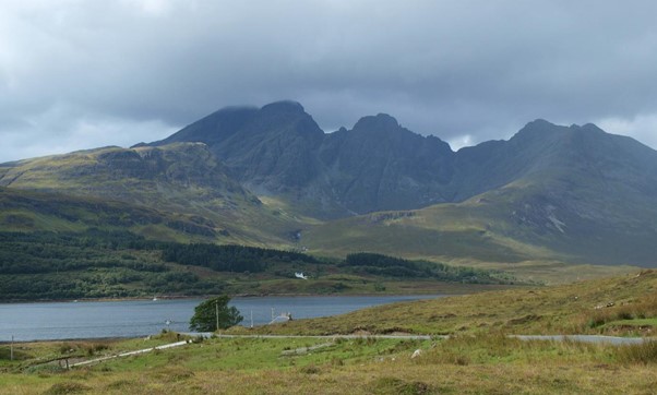
Clouds over the Cuillins. At least it was dry (for a little while).
We are living in an era of high frequency earth observation, with repeated “views” of the same piece of terrain every few days by an ever-expanding constellation of satellites. The ESA Sentinel-2 satellite pair, for example, provide global coverage of 10-m resolution imagery every 5-6 days, with multispectral observations of surface reflectance spanning the visible spectrum (blue, green and red), near infra-red and short-wave infrared wavelengths. This multi-temporal monitoring system has opened up a world of possibility for large-scale optical remote sensing: even in very cloudy settings, eventually there will be an opening in the clouds.
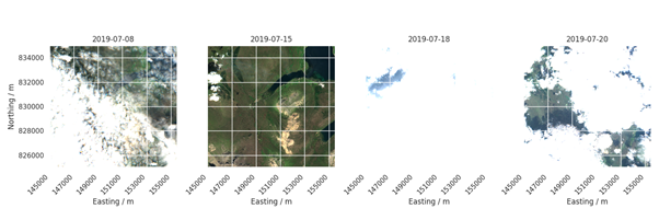
A Sentinel-2 view of the central Skye (Cuillin Hills in the southwest corner); four consecutive scenes captured between 8th and 20th July, 2019; the field of view is ~10 km across. A fine summer day on the 15th July provides a near cloud-less view, but most scenes are subject to a high level of cloud cover.
The challenge in developing scalable applications therefore centres on automating procedures to mine huge datasets to accurately find cloud-free views of every location across large regions and bring them together in a way that makes analysis easy. Developed by researchers at the University of Edinburgh in collaboration with the Edinburgh Performance Computing Centre (EPCC), and working in some of the world’s cloudiest landscapes in NW Scotland, OptiView is Data Slipstream’s solution to this challenge.
The OptiView system uses a novel approach that exploits the combination of repeat views and spectral range of the Sentinel 2 constellation. The repeated views allow accurate mapping of regions obscured by cloud and cloud-shadow based on the change in surface reflectance from one scene to the next. These temporal cloud-detection algorithms are generally superior to attempts to classify clouds in individual scenes. The OptiView system then combines cloud-free views into a spatially continuous mosaic: a ready-to-use, wall-to-wall, cloud-free view of the land surface, perfect for eye-catching visuals and integrating into analytical pipelines, even for the world’s cloudiest places.
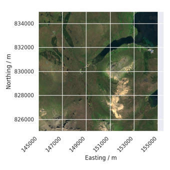
OptiView scene for the same view of central Skye as above (Cuillin Hills in the southwest corner), based on Sentinel-2 imagery acquired in June and July 2019; the field of view is ~10 km across.